Wednesday, October 7, 2015

Leaving Arizona

We left Palm Creek with no real travel plans other than to head to New Mexico and do some exploring.  Our first stop was Benson, AZ where we finally started doing some exploring of the local area.  We spent a week at the Butterfield RV resort (we wanted to stay at the Escapees Park but it was full).  We visited Tombstone, a real tourist trap and something to avoid, and Kartchner Caverns which is a must see.  Since we had to go into Tucson to get some dog medication, we did manage to sneak in the Pima County Air Museum as well.  A must see for aircraft enthusiasts.  Butterfield has an operating observatory on the property that is open every night,  weather permitting.  If we took pictures, we can't find them.

From Benson, we headed to Las Cruces, NM and we really haven't left.

As full timers you are always aware that at some point you are going to come off the road and settle in one spot.  We had figured we would do that after 5-10 years (we would be in our mid to late 70's) and in the meantime we would keep looking for that perfect spot.  We had looked at Las Cruces as a possible retirement place before we had jumped into motorhoming but decided running around in the motorhome was more fun.  As a lark, we contacted the realtor we had talked to 4 years before and he was still in Las Cruces and still working for the same firm.

We kind of hit the perfect storm.  With a good inventory of quality homes, great prices, and interest rates really low, buying a home now and using it as a base for more travel it really seemed like the thing to do.  So, we are now official residents of Las Cruces, NM.

Front, looking towards the south west

Front, looking towards the south east.  The open patch of gravel looks big enough for a motorhome!!!
And it is.  It is big enough that we can open all the slides and best of all, it has full hookups.  We just happened to have a sewer cleanout on that side, plus the electrical box, and soft water.  So we have a 50 amp full hookup site.

So why Las Cruces?

Scenic beauty certainly plays a big part of why you like an area.  Las Cruces is surrounded by the various pieces of the Organ Mountains National Monument.  Towering volcanic spires in your backyard are always nice.

Organ Mountains from just west of downtown Las Cruces

From the upper mesa.  The highest needles are about 9500 ft.  The valley floor around Las Cruces is about 4000 ft.
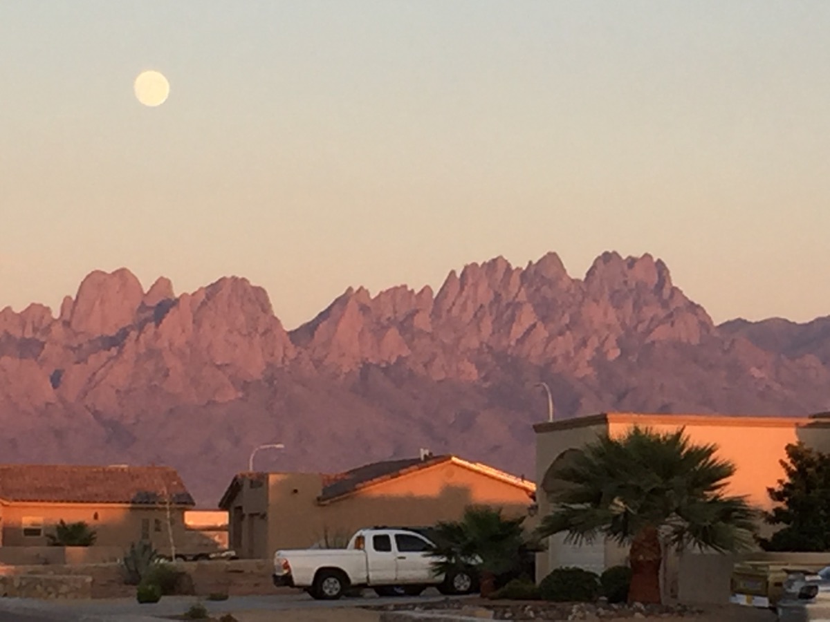
And from our neighborhood.

Just over the hill (east of Las Cruces) is the White Sands National Monument.  The sands are really gypsum (the stuff inside of drywall) and are very different than sand.  First off, in the hottest weather, you can walk on the sands barefoot and not be burnt.  You can sled on it and you can die out there amongst it.  We had a French couple who were hiking one of the trails this summer with their son.  They did not take adequate water with them and the parents died, the son lived.  

White Sands vs. real snow.  The white dot in the middle of the picture is snow on one of the mountain peaks.  It's probably 50 mi or so from where the picture was taken.

Except for the bits of green, you could be in the Dakotas in mid winter.

And you could be sledding almost anywhere in the rest of the US in winter, but not shorts.

The climate isn't bad.  Sure it gets hot in the summer - mostly in the 90's, but it doesn't feel like the 90's when you compare it to anywhere with humidity.  We experienced some of Spring and it was pleasant but Fall this year has remained hot.  We are going to miss Winter as we are cranking up the motorhome and heading off to Florida.

We haven't sat in one spot the whole time we have been in Las Cruces.  We did take a side trip to Carlsbad (we never take pictures is caves although Carlsbad allows and encourages photography).  I guess we will have to return.  Also on that swing were Roswell (sorry, the aliens weren't home) and Albuquerque.  

Our oldest son, Sean, was a balloon pilot and trained in Albuquerque and flew in a couple of the Festivals as well in the late 90's.  We want to visit the area where we scattered his ashes.  We had originally planned to do it during a flight in the 2000 Festival but the weather was horrible.  So we opted to climb up one of the cinder cones in the Petroglyph National Monument and do that.  The area overlooks the area where balloon pilots are trained so we felt that it was an appropriate resting place.  You can see the cinder cones to the west of the the Rio Grande and I-25 as you are driving south towards I-40.

And you can thank Sean for the URL of this blog as well.  This was his response to his brother when an eel, caught in a crab trap, slithered out and across the dock and back into the Chesapeake Bay.  The whole statement was "Don't worry, eel be back".  Till next time.

Saturday, March 14, 2015

Our visit to Zion National Park

Zion National Park - October 2014

(from Benson, AZ, March 14, 2015 For a fullsize image, just click on the picture)

Our blog post from last October was not completed as we ran into a large snag - Palm Creek RV Park, where we spent the winter.  With minimal internet coverage we just couldn't get enough band width to up load a few pictures.  Needless to say, I'm not happy with Palm Creek but it is hard to back out of a 2 for 1 deal without serious financial impact.  We are back on the road (yeah!) and we have internet again so it is time to catch up.

We stayed in Hurricane, UT for our visit to Zion National Park.  Very nice little town and not nearly as congested as the area around the main entrance to ZNP.  We also had easy access to the Kolob Canyon portion of ZNP as well.

Zion is unique in that it is really a long, narrow valley, carved by a rather small river, that results in some pretty impressive mountains.  Because vehicle emissions and traffic were creating problems in the valley, the NPS banned vehicular traffic but offered free shuttle buses to tour the valley and service the back country trails.  Works great but you have to get to the visiter center early to find a parking spot.

You can thank the formation of the Rocky Mountains for ZNP.  The uplift of an ancient sea bed ends at I-15 in Utah.  On the west side of I-15 you have the Great Basin, on the east side you have all of the national parks.  Zion sits on the southwest corner of this uplift.

Across the bridge and to the left and you are in the part of the canyon closed to regular traffic.  This is looking towards the east and where the tunnels are located when you exit the park.  We didn't take this road - yet.

View from behind the museum.

View as you enter the canyon.  You are greeted with large vertical surfaces that soar to the sky.


This shallow river carved this entire valley and is still carving it today.
We decided to stay on the road until the last stop and then work our way back down the canyon.  At the very end of the road is a trail that takes you to slot canyons, however, you actually have to hike through a stream to reach them.  
The end of the "dry" trail and the beginning of the "wet" one.


As we walked back towards the bus stop, we spotted a small herd of mule deer along the far bank of the river.  
Looking back down the canyon.

Kolob Canyon

On the western edge of the park is a section known as Kolob Canyon.  This section is only accessible from I-15.  Given the low number of cars in the parking lot, I'd say that most people miss one of the better sections of ZNP.


The road to the canyons.
Like most of Zion, if you can hike, you are in for incredible views.


Because of the large number of photos from this trip, I will be creating a Dropbox album as soon as I get time.  I will post a link when everything is ready.

Wednesday, October 22, 2014

Hanging around the Salt Lake City Area, Part 2

Posted from Hurricane, UT  October 22nd

We decided to visit the Great Salt Lake.  As a kid, I remember going to a State Park and near SLC and swimming and not sinking in the really salty water.  Given it is October, the swimming was out so we tried another approach - visiting Antelope Island State Park.  But first, we ran downtown to Temple Square to see the sights.  Salt Lake City is the headquarters for the Church of Jesus Christ of Latter Day Saints also known as Mormons.  The story of their emigration to Utah can be found elsewhere but the Mormons where one of the three major groups to cross the US by land - Pioneers moving to Oregon, the Mormons, and the California Gold rush all used the same or similar trails across Nebraska, Wyoming, Montana, and Utah.


Mormon Temple

Just some of the beautiful flowers in the gardens in Temple Square

Tabernacle Pipe Organ (free concerts everyday at noon)


Enough of SLC, back to nature!

Antelope Island can only be reached by causeway although due to really low water levels currently, you could probably hike across the salt flats if the brine flies didn't carry you off.  Named for the herds of antelope that were found on the island when John Fremont and Kit Carson explored the island in 1845.  We didn't see any antelope during our visit.  In fact we probably would have named the island after a non-native species we saw in abundance (no not marsh flies although that would seem fitting).


Antelope Island was settled not too long after SLC - 1848 in fact.  The oldest Anglo built structure in Utah is the Fielding Garr ranch on the island.

One section of the causeway that brings you to the island.
The Wasatch Range is in the background.  Sorry for the cloudy day. 
Visitor Center which we didn't get to see due to a dog having separation anxiety from her "Mom".
Zoe was with us on this trip which was good, bad, and pretty funny.  We wanted to see the visitor center but Zoe put up such a ruckus that if she was human she would have been banished to her room for a cooling off period of several hours.  So instead, she visited a few of the outdoor exhibits (like the white buffalo in the picture above) or the bronze mule deer below.


Zoe started growling at the buffalo but got really charged up when I tried to introduce her to the deer.  Hackles up, lots of growling, and lots of human laughter.  Very funny dog reaction.

Well off on our drive to the ranch.  We soon figured out what the island should be named.


How about Bison or Buffalo Island?  They have an estimated 500-700 animals in the herd and yes, we saw them all.  They have an annual buffalo roundup like Custer State Park in South Dakota.  Camping rates soar for Round Up weekend (just like Custer) - must be a western thing.

More causeway
A view to the North.  Normally this would be all water but maybe this Spring, after the snow melt, the levels will rise again.
I wish we had more time and nicer weather to explore Antelope Island.  The haze really spoiled the pictures.  Oh well, off to Hurricane, UT for our next stop.

Tuesday, October 21, 2014

Hanging around the Salt Lake City Area, Part 1

Posted from Hurricane, UT  October 21st

We decided to spend a few days in the Salt Lake area.  Being former suburbanites, we normally we don't like to spend time in heavily industrialized urban areas but it was either that or another 100 miles through heavy traffic.  For those of you who have never been to Utah, it seems as though 95% of the population lives in a 120 mile stretch of I-15.  Seems just like LA in many ways (although the crime rate is probably lower).  When the air pollution is low, the Wasatch Range behind SLC provides a beautiful back drop to the city.

There is a rather pleasant set of gardens behind the University of Utah campus.  Our first visit was to Red Butte Gardens.  The Garden is in transition between Summer and Fall plantings.  The Garden was setting up for Halloween with special after dark paths through the complex.  Should be lots of fun in a few more days.
Entrance

We liked the rusted steel sculpture.  Even the trash barrel is laser carved.

Herb garden

Part of a large children's garden.

Looking across the valley towards the copper mine.

Western Chickadee

The lower pool of a rather large water feature.  This is a natural stream.

We had a pleasant lunch at an Irish Pub nearby and then back to the Pony Express RV Park.  Just a few words about the Pony Express RV Park - very clean, all concrete pads, full hook ups but the sites are bit close together for our tastes.  You are surrounded by highways (not too noisy unless you are close to the outer edges), 2 oil refineries, and the City of Salt Lake sewage treatment plant about a mile south.  At times, smells were very interesting.

Tuesday, October 14, 2014

Arco, ID

From North Salt Lake City, UT

We spent 4 nights at Mountain View RV Park in Arco, ID as part of our visit to Craters of the Moon.  Nice campground with new owners who are beginning to make some improvements.  A little pricey but their only competition is a KOA.

I Googled the Top Ten Things to See in Arco, and Google returned "The Top Two Things to See in Arco" which I thought was pretty funny.  The top two things were Craters of the Moon and the EBBR at the Idaho National Lab.  The EBBR (experimental breeder reactor) was only open from Memorial Day to Labor Day.  Oh well.

Arco does have a few things to see however.

Number Mountain - Butte High School tradition dating from 1920.  Each graduating class paints their class year on the cliffs on the mountain.


Sail from the USS Hawkbill - I still haven't figured this on out.  There was no information that tied the Hawkbill to anyone or anything in Arco.  It just kind of showed up, I guess.


And finally, Big Southern Butte - another volcano about 25 miles from Arco.

Off to Salt Lake City...

Craters of the Moon National Monument

From North Salt Lake City, Utah


We had decided earlier this summer to visit Craters of the Moon National Monument if we were close to the area.  Waiting to later in the year to visit was a great idea since it can get quite warm out on the lava beds when the sun beating down.

Geologically speaking, this was the place to be about 2000 years ago when the volcanos begin erupting.  These weren't the big towering volcanos seen in Hawaii, Alaska, and along the Cascades, but kind of small oozey ones.  This area is known as the Great Rift for the way volcanos erupted along a rift in the earth's surface.  This area is also part of an area in the earth's crust which has moved from northeast California to it's present location in Wyoming.  Yellowstone National Park sits on top of the very top of the same type of structure which formed Craters of the Moon.

Astronauts did train here prior to the moon landings.  Mary and I remember the Mercury, Gemini, and Apollo missions as they all happen during our years in elementary, junior high, high school, and college years.  We had been married two weeks when the first moon landings took place.

If you want to study lava, Craters is a lot closer than Hawaii.  Craters has examples of most types of volcanic rock produced from the smooth pahoehoe, the really rugged a', a, cinders, to lava bombs, cinder cones and kipukas (islands).


Example of pahoehoe lavas.


And a', a lava.

You can easily walk across pahoehoe, but a', a will shred you boots because of the sharp, exposed edges.  

Vegetation is pretty sparse in the lava flows but it isn't non-existent.  Even the barest areas seems to have something growing in them.  We found out it is called dwarf buckwheat.


And it blooms (although normally only in the Spring)


Cinder cones are the last dying gasp of a volcano.  Craters has an area with a number of them, including two you can climb to the top and look down the throat.


Kipukas are islands of normal terrain that was surrounded by lava flows.  They become sanctuaries to plants and animals.  The ones in Crater are not accessible to visitors.  This one is several miles from the closest road.


The last feature of Crater are the lava caves, which we did not visit.  These are free caves, i.e. they are not developed and you are completely on your own if you visit them.  

Craters of the Moon is a worthwhile stop.  You can easily tour the entire park in one day (pack a lunch as there is nothing closer than 20 miles away), bring plenty of water (it is extremely dry and the wind blows constantly, and be sure and catch the two movies about the park.