Wednesday, October 22, 2014

Hanging around the Salt Lake City Area, Part 2

Posted from Hurricane, UT  October 22nd

We decided to visit the Great Salt Lake.  As a kid, I remember going to a State Park and near SLC and swimming and not sinking in the really salty water.  Given it is October, the swimming was out so we tried another approach - visiting Antelope Island State Park.  But first, we ran downtown to Temple Square to see the sights.  Salt Lake City is the headquarters for the Church of Jesus Christ of Latter Day Saints also known as Mormons.  The story of their emigration to Utah can be found elsewhere but the Mormons where one of the three major groups to cross the US by land - Pioneers moving to Oregon, the Mormons, and the California Gold rush all used the same or similar trails across Nebraska, Wyoming, Montana, and Utah.


Mormon Temple

Just some of the beautiful flowers in the gardens in Temple Square

Tabernacle Pipe Organ (free concerts everyday at noon)


Enough of SLC, back to nature!

Antelope Island can only be reached by causeway although due to really low water levels currently, you could probably hike across the salt flats if the brine flies didn't carry you off.  Named for the herds of antelope that were found on the island when John Fremont and Kit Carson explored the island in 1845.  We didn't see any antelope during our visit.  In fact we probably would have named the island after a non-native species we saw in abundance (no not marsh flies although that would seem fitting).


Antelope Island was settled not too long after SLC - 1848 in fact.  The oldest Anglo built structure in Utah is the Fielding Garr ranch on the island.

One section of the causeway that brings you to the island.
The Wasatch Range is in the background.  Sorry for the cloudy day. 
Visitor Center which we didn't get to see due to a dog having separation anxiety from her "Mom".
Zoe was with us on this trip which was good, bad, and pretty funny.  We wanted to see the visitor center but Zoe put up such a ruckus that if she was human she would have been banished to her room for a cooling off period of several hours.  So instead, she visited a few of the outdoor exhibits (like the white buffalo in the picture above) or the bronze mule deer below.


Zoe started growling at the buffalo but got really charged up when I tried to introduce her to the deer.  Hackles up, lots of growling, and lots of human laughter.  Very funny dog reaction.

Well off on our drive to the ranch.  We soon figured out what the island should be named.


How about Bison or Buffalo Island?  They have an estimated 500-700 animals in the herd and yes, we saw them all.  They have an annual buffalo roundup like Custer State Park in South Dakota.  Camping rates soar for Round Up weekend (just like Custer) - must be a western thing.

More causeway
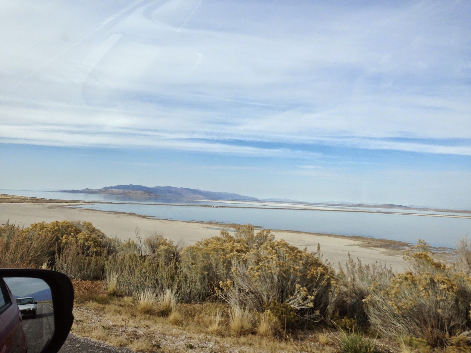
A view to the North.  Normally this would be all water but maybe this Spring, after the snow melt, the levels will rise again.
I wish we had more time and nicer weather to explore Antelope Island.  The haze really spoiled the pictures.  Oh well, off to Hurricane, UT for our next stop.

Tuesday, October 21, 2014

Hanging around the Salt Lake City Area, Part 1

Posted from Hurricane, UT  October 21st

We decided to spend a few days in the Salt Lake area.  Being former suburbanites, we normally we don't like to spend time in heavily industrialized urban areas but it was either that or another 100 miles through heavy traffic.  For those of you who have never been to Utah, it seems as though 95% of the population lives in a 120 mile stretch of I-15.  Seems just like LA in many ways (although the crime rate is probably lower).  When the air pollution is low, the Wasatch Range behind SLC provides a beautiful back drop to the city.

There is a rather pleasant set of gardens behind the University of Utah campus.  Our first visit was to Red Butte Gardens.  The Garden is in transition between Summer and Fall plantings.  The Garden was setting up for Halloween with special after dark paths through the complex.  Should be lots of fun in a few more days.
Entrance

We liked the rusted steel sculpture.  Even the trash barrel is laser carved.

Herb garden

Part of a large children's garden.

Looking across the valley towards the copper mine.

Western Chickadee

The lower pool of a rather large water feature.  This is a natural stream.

We had a pleasant lunch at an Irish Pub nearby and then back to the Pony Express RV Park.  Just a few words about the Pony Express RV Park - very clean, all concrete pads, full hook ups but the sites are bit close together for our tastes.  You are surrounded by highways (not too noisy unless you are close to the outer edges), 2 oil refineries, and the City of Salt Lake sewage treatment plant about a mile south.  At times, smells were very interesting.

Tuesday, October 14, 2014

Arco, ID

From North Salt Lake City, UT

We spent 4 nights at Mountain View RV Park in Arco, ID as part of our visit to Craters of the Moon.  Nice campground with new owners who are beginning to make some improvements.  A little pricey but their only competition is a KOA.

I Googled the Top Ten Things to See in Arco, and Google returned "The Top Two Things to See in Arco" which I thought was pretty funny.  The top two things were Craters of the Moon and the EBBR at the Idaho National Lab.  The EBBR (experimental breeder reactor) was only open from Memorial Day to Labor Day.  Oh well.

Arco does have a few things to see however.

Number Mountain - Butte High School tradition dating from 1920.  Each graduating class paints their class year on the cliffs on the mountain.


Sail from the USS Hawkbill - I still haven't figured this on out.  There was no information that tied the Hawkbill to anyone or anything in Arco.  It just kind of showed up, I guess.


And finally, Big Southern Butte - another volcano about 25 miles from Arco.

Off to Salt Lake City...

Craters of the Moon National Monument

From North Salt Lake City, Utah


We had decided earlier this summer to visit Craters of the Moon National Monument if we were close to the area.  Waiting to later in the year to visit was a great idea since it can get quite warm out on the lava beds when the sun beating down.

Geologically speaking, this was the place to be about 2000 years ago when the volcanos begin erupting.  These weren't the big towering volcanos seen in Hawaii, Alaska, and along the Cascades, but kind of small oozey ones.  This area is known as the Great Rift for the way volcanos erupted along a rift in the earth's surface.  This area is also part of an area in the earth's crust which has moved from northeast California to it's present location in Wyoming.  Yellowstone National Park sits on top of the very top of the same type of structure which formed Craters of the Moon.

Astronauts did train here prior to the moon landings.  Mary and I remember the Mercury, Gemini, and Apollo missions as they all happen during our years in elementary, junior high, high school, and college years.  We had been married two weeks when the first moon landings took place.

If you want to study lava, Craters is a lot closer than Hawaii.  Craters has examples of most types of volcanic rock produced from the smooth pahoehoe, the really rugged a', a, cinders, to lava bombs, cinder cones and kipukas (islands).


Example of pahoehoe lavas.


And a', a lava.

You can easily walk across pahoehoe, but a', a will shred you boots because of the sharp, exposed edges.  

Vegetation is pretty sparse in the lava flows but it isn't non-existent.  Even the barest areas seems to have something growing in them.  We found out it is called dwarf buckwheat.


And it blooms (although normally only in the Spring)


Cinder cones are the last dying gasp of a volcano.  Craters has an area with a number of them, including two you can climb to the top and look down the throat.


Kipukas are islands of normal terrain that was surrounded by lava flows.  They become sanctuaries to plants and animals.  The ones in Crater are not accessible to visitors.  This one is several miles from the closest road.


The last feature of Crater are the lava caves, which we did not visit.  These are free caves, i.e. they are not developed and you are completely on your own if you visit them.  

Craters of the Moon is a worthwhile stop.  You can easily tour the entire park in one day (pack a lunch as there is nothing closer than 20 miles away), bring plenty of water (it is extremely dry and the wind blows constantly, and be sure and catch the two movies about the park.

Friday, September 26, 2014

Glacier National Park - East Side, Part 2

Caldwell, ID  September 26


It was getting fairly late when we headed for the border but after dodging a fair number of open range cows in a forested area (Tip, look for cattle poop on the road.  If you see it, be really alert because a cow or cows are close by.) we made it.


Only to wait, and wait, and wait some more.  About 45 minutes of waiting.  This is not a fulltime border crossing but still.  Only one person checking people through for Canada so one vehicle at a time please.  BTW, on the US side they could handle two cars and a truck/RV at one time.

We waited so long, we were taking pictures of birds (these are US Western Jays, BTW).


And trying to figure out if this was Chief Mountain or not.  Note the semi-wild cows.


We don't think it was Chief Mountain but Sofa Mountain.  If anyone knows, please let us know.

Once we got into Canada, we quickly switched to metric (do it fast or you can get a speeding ticket) and we were off.  The mountains on the Canadian side seem to rise out of the prairie.  This was unexpected on our part as we thought the mountains just kept going into the Canadian Rockies.


We saw a sign announcing the turn off to Red Rock Canyon so with our sense of adventure still in tact, took the turn off and headed off through the boondocks.  We hadn't noticed a great number of red rocks anywhere but we got to the parking lot and found a rather small canyon but nice red, rocks:


The stream has cut down through the over burden and exposed a rather pretty layer of red rocks.  What we thought was rather neat was you couldn't keep people out of the water.  Despite cool temperatures a rain showers, everyone (but not us) wanted play in the creek.  It was hard getting pictures without people.

We headed back towards Waterton to get some pictures of the Price of Wales Hotel (built by the Canadian Railroad for tourist purposes).  We got stopped by a bear jam (happens in Canada as well) and we didn't even spot the bear.

Well, the hotel is still standing and rather attractive.  Our Red Bus tour guide told is that is was so windy on the site that the hotel kept blowing down during construction.  I believe it as it was so windy on the point that it was hard to stand to take photos.


And before we started our return journey, a photo looking south down Upper Waterton Lake towards the USA.  

We journeyed back via Going to the Sun Road and wished we were on the Red Bus.  While you can sneak peaks at the scenery, driving the road is pretty much a fulltime job.

This is the last blog in the Glacier National Park series.  We throughly enjoyed the experience and our only regret was that we were unable to enjoy taking some of the hikes into the back country.

We headed back to Missoula to get restocked, enjoy Jim and Mary's RV Park and all of it's flowers, and get the motorhome's annual service.  We started to really like Missoula - especially the Saturday Farmer's Markets and we plan to visit again.

Glacier National Park - East Side, Part 1

Caldwell, ID  September 26

To finish off our trip to Glacier, we decided to visit the East areas we hadn't seen, primarily Two Medicine and Waterton Lakes National Park in Canada.  We also decided to follow US 2 East around the southern end of the park to East Glacier.  If you like mountain vistas, mountain railroads, scenic vistas of the Flathead River, and no people, this is the road for you.  For the most part the road stays outside of the park except for a small area known as Goat Lick.  The goats stop by this cut in the Flathead for minerals found in the local rocks.  The goats normal time to visit is the Spring and it was the end of Summer, so sorry, no goats or pictures.

Since the park straddles the Continental Divide, you have to cross it again at Marias Pass.  As we crested the pass we were greeted with with rainbows that lasted all of the way to the Two Medicine turn off.


Well, what could top that?  By the time we got to Two Medicine, the clouds and drizzle had moved back in so we didn't stay too long.


All of the lakes that have road access seem to have a boat ride available.  So if you like boat rides, you can tour Lake McDonald, Two Medicine Lake, Lake St. Mary, and Swiftcurrent lake at Many Glacier.

The outflow from Two Medicine Lake forms Running Eagle creek which creates a rather unique waterfall on it's way to Lower Two Medicine Lake.  The water fall just seems to spring from the local rock.


We travelled on to the Saint Mary Visiter Center for a picnic lunch break.  It wasn't much of a picnic however, since the wind was blowing in excess of 40 mph through the area, but it was a nice visiter center.  After lunch, we headed for Canada.

Wednesday, September 24, 2014

Glacier National Park - West Side

Caldwell, ID  September 24th

We decided to take a drive up the west side of Glacier towards Canada.  You can drive all the way to the border but there is no longer a crossing open.  There is even a rougher road inside the park that is more suitable for 4-wheel drive but a large stretch of that road is closed due to bridge being out.  After being on the road for a while, it is completely understandable - its a gravel road almost the whole way up.

The first stop was the Fish Creek Campground and Picnic area on Lake McDonald.  We just wanted to see the lake and walk around.  Turned out to be a gorgeous day and the shift in perspective seeing the mountains that make up the Logan Pass area was amazing.


This side of Glacier had a fire and so we drove through a few miles of dead trees but the interesting thing was the regrowth going on underneath the dead trees.  The tree trunks you see standing are lodgepole pines which actually need fire to spread their seeds.


The whole west side of Glacier really is for backpackers.  There lots of nice forests and mountains that no roads cross.


And there are very few people in this area.  The biggest is Polebridge and it can't get much more remote than this.


The mountain range just north of Polebridge is very close to the Canadian border according to the park map.  Had we continued on the road past Polebridge we would have come to another glacier created lake, Bowman Lake, that is about 1/4 the size of Lake McDonald.

The area was pretty lush with new growth and we really expected to see some wildlife.  No such luck on this trip - no four footed wildlife but we did find some pretty six legged ones.


Our next trip in Glacier was to visit the East side - from Two Medicine to Waterton Park in Canada.