Friday, September 26, 2014

Glacier National Park - East Side, Part 2

Caldwell, ID  September 26


It was getting fairly late when we headed for the border but after dodging a fair number of open range cows in a forested area (Tip, look for cattle poop on the road.  If you see it, be really alert because a cow or cows are close by.) we made it.


Only to wait, and wait, and wait some more.  About 45 minutes of waiting.  This is not a fulltime border crossing but still.  Only one person checking people through for Canada so one vehicle at a time please.  BTW, on the US side they could handle two cars and a truck/RV at one time.

We waited so long, we were taking pictures of birds (these are US Western Jays, BTW).


And trying to figure out if this was Chief Mountain or not.  Note the semi-wild cows.


We don't think it was Chief Mountain but Sofa Mountain.  If anyone knows, please let us know.

Once we got into Canada, we quickly switched to metric (do it fast or you can get a speeding ticket) and we were off.  The mountains on the Canadian side seem to rise out of the prairie.  This was unexpected on our part as we thought the mountains just kept going into the Canadian Rockies.


We saw a sign announcing the turn off to Red Rock Canyon so with our sense of adventure still in tact, took the turn off and headed off through the boondocks.  We hadn't noticed a great number of red rocks anywhere but we got to the parking lot and found a rather small canyon but nice red, rocks:


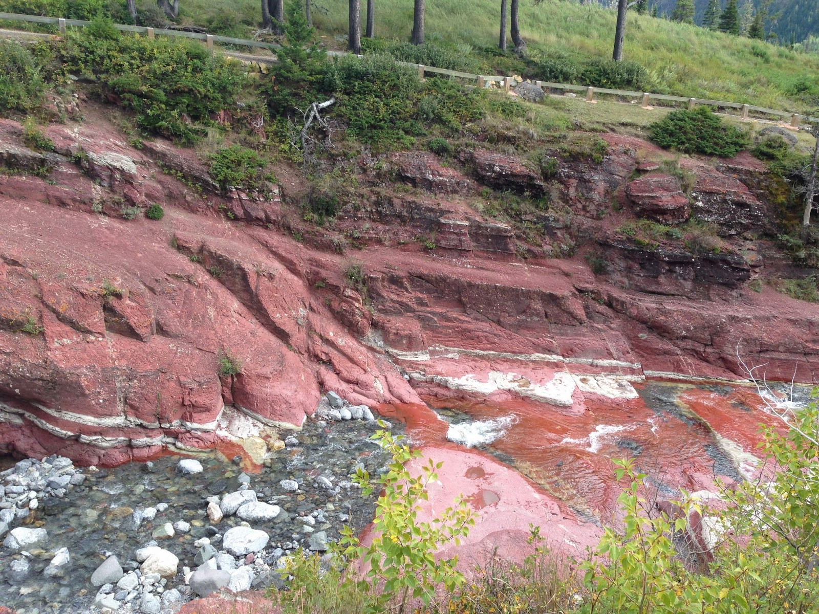
The stream has cut down through the over burden and exposed a rather pretty layer of red rocks.  What we thought was rather neat was you couldn't keep people out of the water.  Despite cool temperatures a rain showers, everyone (but not us) wanted play in the creek.  It was hard getting pictures without people.

We headed back towards Waterton to get some pictures of the Price of Wales Hotel (built by the Canadian Railroad for tourist purposes).  We got stopped by a bear jam (happens in Canada as well) and we didn't even spot the bear.

Well, the hotel is still standing and rather attractive.  Our Red Bus tour guide told is that is was so windy on the site that the hotel kept blowing down during construction.  I believe it as it was so windy on the point that it was hard to stand to take photos.


And before we started our return journey, a photo looking south down Upper Waterton Lake towards the USA.  

We journeyed back via Going to the Sun Road and wished we were on the Red Bus.  While you can sneak peaks at the scenery, driving the road is pretty much a fulltime job.

This is the last blog in the Glacier National Park series.  We throughly enjoyed the experience and our only regret was that we were unable to enjoy taking some of the hikes into the back country.

We headed back to Missoula to get restocked, enjoy Jim and Mary's RV Park and all of it's flowers, and get the motorhome's annual service.  We started to really like Missoula - especially the Saturday Farmer's Markets and we plan to visit again.

Glacier National Park - East Side, Part 1

Caldwell, ID  September 26

To finish off our trip to Glacier, we decided to visit the East areas we hadn't seen, primarily Two Medicine and Waterton Lakes National Park in Canada.  We also decided to follow US 2 East around the southern end of the park to East Glacier.  If you like mountain vistas, mountain railroads, scenic vistas of the Flathead River, and no people, this is the road for you.  For the most part the road stays outside of the park except for a small area known as Goat Lick.  The goats stop by this cut in the Flathead for minerals found in the local rocks.  The goats normal time to visit is the Spring and it was the end of Summer, so sorry, no goats or pictures.

Since the park straddles the Continental Divide, you have to cross it again at Marias Pass.  As we crested the pass we were greeted with with rainbows that lasted all of the way to the Two Medicine turn off.


Well, what could top that?  By the time we got to Two Medicine, the clouds and drizzle had moved back in so we didn't stay too long.


All of the lakes that have road access seem to have a boat ride available.  So if you like boat rides, you can tour Lake McDonald, Two Medicine Lake, Lake St. Mary, and Swiftcurrent lake at Many Glacier.

The outflow from Two Medicine Lake forms Running Eagle creek which creates a rather unique waterfall on it's way to Lower Two Medicine Lake.  The water fall just seems to spring from the local rock.


We travelled on to the Saint Mary Visiter Center for a picnic lunch break.  It wasn't much of a picnic however, since the wind was blowing in excess of 40 mph through the area, but it was a nice visiter center.  After lunch, we headed for Canada.

Wednesday, September 24, 2014

Glacier National Park - West Side

Caldwell, ID  September 24th

We decided to take a drive up the west side of Glacier towards Canada.  You can drive all the way to the border but there is no longer a crossing open.  There is even a rougher road inside the park that is more suitable for 4-wheel drive but a large stretch of that road is closed due to bridge being out.  After being on the road for a while, it is completely understandable - its a gravel road almost the whole way up.

The first stop was the Fish Creek Campground and Picnic area on Lake McDonald.  We just wanted to see the lake and walk around.  Turned out to be a gorgeous day and the shift in perspective seeing the mountains that make up the Logan Pass area was amazing.


This side of Glacier had a fire and so we drove through a few miles of dead trees but the interesting thing was the regrowth going on underneath the dead trees.  The tree trunks you see standing are lodgepole pines which actually need fire to spread their seeds.


The whole west side of Glacier really is for backpackers.  There lots of nice forests and mountains that no roads cross.


And there are very few people in this area.  The biggest is Polebridge and it can't get much more remote than this.


The mountain range just north of Polebridge is very close to the Canadian border according to the park map.  Had we continued on the road past Polebridge we would have come to another glacier created lake, Bowman Lake, that is about 1/4 the size of Lake McDonald.

The area was pretty lush with new growth and we really expected to see some wildlife.  No such luck on this trip - no four footed wildlife but we did find some pretty six legged ones.


Our next trip in Glacier was to visit the East side - from Two Medicine to Waterton Park in Canada.

Red Bus Tour, Part 2 Logan's Pass to Many Glacier

Caldwell, ID  September 23


Glacier National Park is just one stunning view after another.  On our way down from Logan Pass you realize that you are on the Eastern Slope of the Continental Divide.  We had just crossed it the day before on I-90 and here we were going  back over the hump.  

We hadn't gone too far down the road towards St. Mary when a couple of us saw movement against the mountain.  Between our driver and one other passenger, they located what turned out to be a Rocky Mountain Goat.  In the next two pictures, see if you can spot the white.  Hint:  Clicking on the pictures will give you a larger view and zooming on the second one will reveal the animal.


We had seen two goats earlier walking across a grassy area but were not able to get a picture due to traffic near Logan Pass.  I wasn't too sure about this photo either until I could look at it on the computer.


Since glaciers are retreating. it is sometimes difficult to tell the difference between a glacier and left over snow from the previous year.  This is Jackson Glacier and is one of the larger ones at 250 acres.


Glacier has two major glacier created lakes that are easily accessible by car.  On the West side it is Lake McDonald and on the east side it Lake St. Mary.  Our route took us almost the entire length of Lake St. Mary as we came down the mountain from Logan pass.

Our lunch break was scheduled for an area in the park known as Many Glacier.  Mountains were spectacular.


And the lodge, like others in the park was built by the railroad to promote the hotel and the park.  This building dates from the 1909, 1910 period.  It still is quite nice and actually overlooks a lovely lake.  Just before we got dropped off at the hotel for lunch, we spotted more wildlife.  How about a grizzly sow and her two cubs.  


The road back from Many Glacier took us back over Going to the Sun Road in the opposite direction.  Not surprisingly, the scenery was much different.  Lots of waterfalls that were not visible to us
This stream formed when an earthquake left a large crack in the side of the mountain.


What is somewhat unique about waterfalls in Glacier is that their water source may actually be on the other side of the mountain.  The underlying rock structure in Glacier is not granite but soft sedimentary rocks from an ancient sea bottom.  Water flows between the rock layers and can seemingly come from nowhere.


Looking back up lake St. Mary towards Logan Pass.  Again, an outstanding view.

The rest of the trip back was pretty uneventful.  We make one last stop, along a river that supplies Lake McDonald for a look at lovely blue color in the water that you get from glacier runoff.


We spent 8.5 hours riding in the Red Bus and visiting the highlights of Glacier National Park.  To be honest, we were pooped and had to take the next day off from exploring.

Our next adventure was up the west side of Glacier.  Not heavily travelled because it is a dirt and gravel road most of the way.

Tuesday, September 23, 2014

Red Bus Tour, Part 1 West Glacier to Logan Pass

 Caldwell, ID  September 23

We opted for the Red Bus Tour of Glacier because unlike our friends Karen and Steve (Gone by RV) we can't go hiking too far.  We both have foot problems which limits our distance severely.  Mary has Shingles related nerve damage and I have several areas in both feet with arthritis damage (bone on bone).  So we rode the bus.

The Red Bus tours are a staple of Glacier National Park.  The original busses were built by White Motors (a truck builder) in the 1930s.  They had wooden frames, cable operated brakes, manual transmissions (drivers were known as jammers since the transmissions had straight tooth, non-synchronized, transmissions which required jamming the transmission into gear and lots of double clutching and noise to shift), and operated unchanged until the 1990s when frame cracking was found and all busses were "grounded".  The park tried other buses but they just didn't have the draw that the Red Busses had.  Ford Motor stepped in and refurbished one bus so dignitaries would have something that worked and carried on the tradition.  After some serious negotiations, the remaining busses were transferred to a non-profit organization and Ford donated the time and labor to refurbish the remaining fleet.  So buses now have 5.4L Ford V8s, automatic transmissions, disc brakes, steel frames and are propane powered.  The bodies are still wood framed just like the original and the experience of touring is pretty much original but a lot safer.

Our bus, #112.  There are 4 rows of seats, each seating 4 people.  The roof rolls back and so we had open air all day.

Our tour took us from the West visiter center to the Lake McDonald Lodge, Logan Pass and on to Many Glacier.  All buses have to have a driver.  Here's ours:

Decker, the driver.
Decker and his wife both work for the park concessionaire, and live in a tent by Lake McDonald.  A little more cavalier than us fulltime RVers.

Besides our aching feet, there's another reason to take the busses - you can't take pictures while driving on the Going to the Sun Road.  It's a bit too narrow and pullouts are kind of hard to find when neat things suddenly appear - like this young grizzly bear. 


Well it was onward and upward towards to Logan Pass after this.


The waterfall in the center of the picture is also the one below.
Yes, the road has steep drop offs and the guard rail is a stone wall.


Looking back down the valley we just came up.  The road is that horizontal line on the right side of the picture.
A bit of glacial sculpting can be seen on this mountain's curved face.
Logan Pass parking lot with a glacier or two behind.

Logan Pass is a popular starting point for a number of trails.  In the picture above, the trail goes in that general direction to Lost Lake and in this picture there is a trail that heads towards Bishop's Hat (the pointy mountain in the left center).  
I believe this is a pika, which is a high altitude ground squirrel.  There are several nests close to the visiter center and these guys don't move.  People apparently don't phase them in the least.

The sad reality of Glacier National Park is that the glaciers are melting and at a rate that says you have only 20-30 years more before they are all gone.  

This is the end of part one.  Next segment covers Logan Pass to Many Glaciers.