Saturday, August 30, 2014

Saying Goodbye to South Dakota

From Glacier National Park, Saturday, August 30th.

We had originally planned on staying only 2 weeks in South Dakota.  We had some legal things to do (our wills) and still had things we wanted to go see in the area.  After two weeks, we still had things we wanted to see in the area.  The Black Hills area has at least a month worth of things to see and do - and that doesn't include the commercial attractions.  So we stayed and played some more.

Our last week in SD and Rapid were not without some some fun.

Badlands Redux

We had planned to visit the Minute Man 1 historic site just outside of the Badlands National Park.  Part of the draw is the descent into an actual control bunker (now decommissioned) that was used during the Cold War.  The number of people allowed on a tour is very limited and when we got to the park "headquarters" (two trailers behind a gas station) we could not get tickets for that day.  What to do.  Well the main Badlands park entrance was just a few miles away so off for a quick transit from East to West.

Just a reminder of what the SD Badlands look like.

I guess you can consider this an arch.  It is pretty obscure and not easy to see from the main road.  We caught a glimpse, took a side road, and found this feature.  There is no access to this that I am aware of, at least no official access. 

We went looking for buffalo (bison to you purists) and found big horn sheep instead.  Who would have thought you would have found these on the plains.

Mom and baby big horns.  These crossed slowly in front of the car a few minutes later.


Custer State Park Redux

Custer State Park might be one of the best parks for tourists to enjoy.  Great wild animal viewing, scenic drives that you truly talk about for years, and very memorable National Monuments.

Views from Iron Mountain Road (taken from various turnouts)


Taken from the base of Mt. Rushmore
Views from The Needles Highway
Yes you can fit a bus through this tunnel.  Tourist buses use the Needles Highway all of the time. but it is narrow, windy, and somewhat less than two lanes in most places.  Great to visit in your toad but your motorhome is not going to fit.  The tourist buses that visit have no roof top attachments and are about 33' to 36' long.  They clear this tunnel with inches (as in 1" to 4") to spare. 

Cars are not a problem.
And last, but not least, a bison jam.  The last week in SD, the bison decided that the Custer State Park Visitor Center was the the place to be.  Normally found on the plains, these guys became mountain bison for a few days.

Time to leave

SD gets some pretty wild storms but we had missed most of them.  One of the worst ones occurred when we were in Scottsbluff.  But this one was a at least a close second.  As soon as the radio started yelling at us, I stepped outside to this:


We pulled the slides in, put the satellite antenna down, and hoped the hail didn't cause too much damage.

The biggest pieces were about golf ball size but most of it was small, pea sized hail.  Sounded pretty dramatic hitting the roof of the motorhome.  The storm was moving so fast that it didn't last too long and no damage was done.

And finally, bye from South Dakota.

Tuesday, August 12, 2014

Devils Tower

Tuesday, August 12, Hermosa, SD

(images have not been resized - click on them for hi-res views)

A couple of weeks ago, we awoke to a great day of sunshine and moderate temperatures and decided to take a road trip to Wyoming and Devils Tower National Monument - yes, the same one in Close Encounters of the Third Kind.  But first, a stop at a couple of unknown Wyoming treasures.

Vore Buffalo Jump

First stop was the Wyoming Welcome Center.  No pictures (unless Mary put it on Facebook) but a great stop.  A bit of a museum, nature center, and tourist promotion kiosk.  Whatever it was, it was done right.  If you are traveling on I-90 in Eastern Wyoming, you should stop.  The second was something we didn't anticipate - The Vore Buffalo Jump.


This was discovered in the late 1960s during the construction of I-90.  Even the Vore family who owned the land didn't know what they had.  Surveyors discovered a sink hole right in the middle of the prospective highway.  The Vore family had used it as trash dump (what else do you do with a big hole in the middle of your property) and the road guys figured they had better do some investigations before the just filled it in and paved it.  They did some test bores and discovered a bone pile that dated back to the 1500s when the native americans first started using it to harvest buffalo.  The layers are so distinct that the exact years it was in use can be established.  Native americans stopped using this harvest method when they obtained firearms in the 1800s.
Active digging area
The area is administered by the Vore Buffalo Jump Foundation and is an active training site for archeology students.  The estimate is that 20,000 buffalo were harvested here during the 300 years it was in use.  The Plains indians relied heavily on the buffalo as a source of food, shelter, clothing.
Buffalo skull

Devils Tower

After the nice, unexpected break, we set off for Devi's Tower.  This really should be on your "Do not miss" list of North America.  The drive to the tower is beautiful - the high northern plains remain easy on the eyes with grasslands and pine trees making you wish you could just stay there all year.
First siting 
 The tower is a product of erosion.  While the material that makes up the tower is igneous in origin, it was thought to never have reached the surface.  This area was once part of an inland sea and was eroded by water and wind.  The tower,  being of much harder material was revealed over hundreds of millions of years.
Just a few miles away
 The first national monument in the United States was named in 1906 by President Theodore Roosevelt - Devils Tower.  The Tower also plays a significant role in Native American history and lore and is considered a sacred site to some tribes.  By the way, the name, Devils Tower, was the result of a bad translation into English by an early explorer.
Still about a mile from the entrance

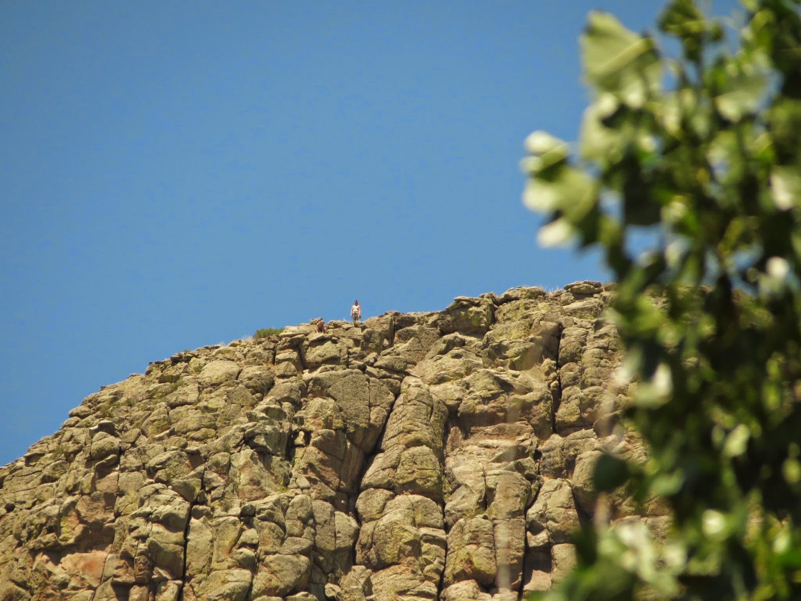
Climber at the summit
 Devils Tower is very popular with climbers.  It was first climbed in the 1890s using a 300' long wooden ladder.  The first technical climb was in 1937.  We noticed this young women at the top when we were eating lunch in the picnic area.
Climbers in route
 And these climbers at the top of a column ready to start their assent.
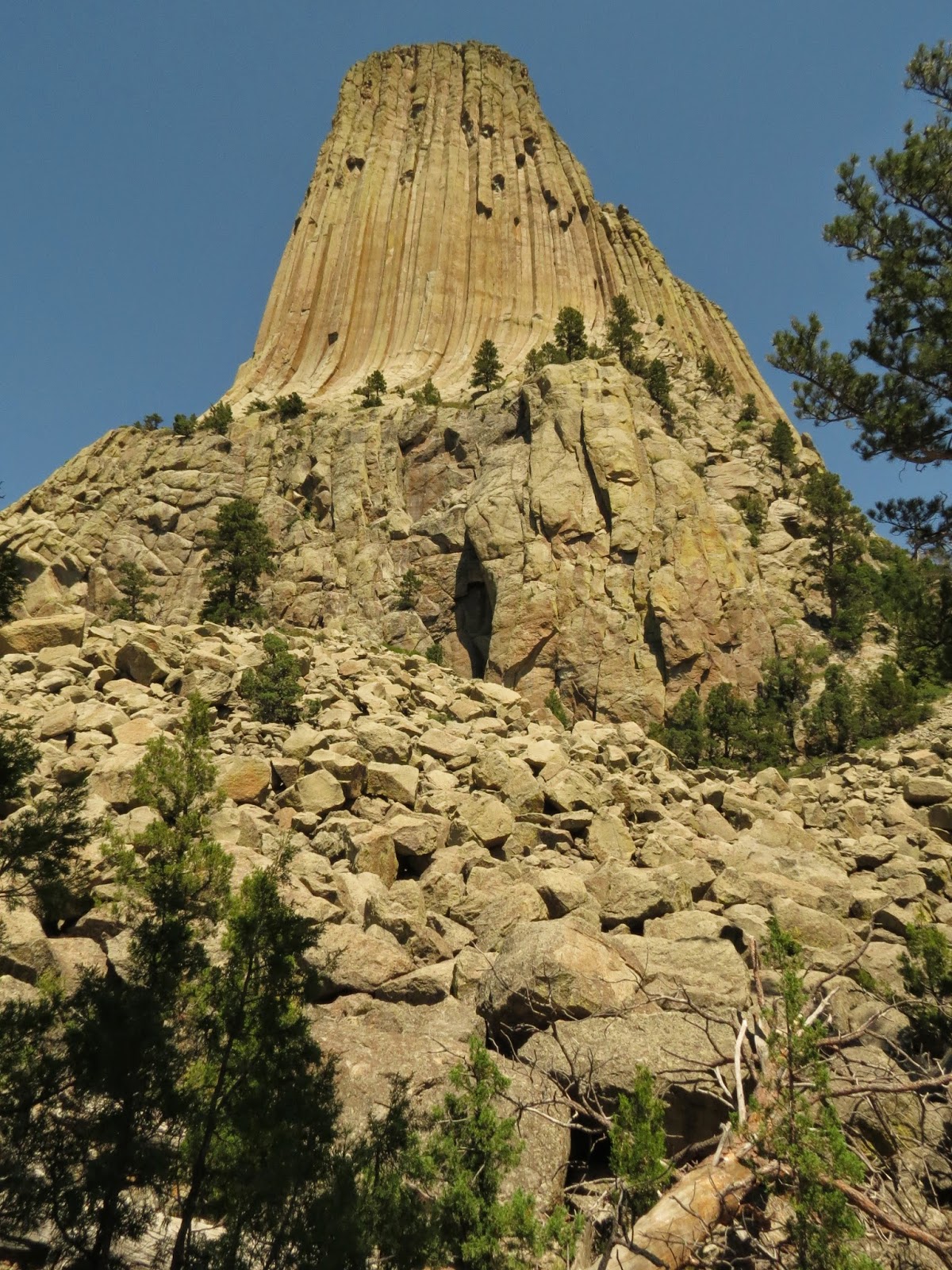
View from the trail around the base
 You can easily get a 360 degree perspective of the tower by taking the 1 mile hike around the base.
Remnants of the wood ladder used to scale the dome the first time

View from the prairie dog village
 A trip to a National anything around these parts wouldn't be complete without a visit to the prairie dog village.  Cute, social, and very protected within National Park or Monument borders, these guys are everywhere.
Prairie dog


Monday, August 11, 2014

Back to Nebraska

Monday, August 11

My retirement "job" is doing presentations to my fellow diabetics about how to do a better job managing their diabetes.  I've been managing my diabetes successfully since 1990 and it really isn't that big of deal - if you want to.  Diabetes is, in fact, my favorite chronic disease.  Why?  Because you can manage it yourself without a lot of intervention from your medical professionals.  Equipped with my glucose meter and my smart phone (and most recently my insulin pump) I've got everything I need to keep my blood sugar in my target range.

So, we (Mary got to go with me on this one) headed back to Nebraska, sans the RV, to do a program for the local hospital in Scottsbluff.  And what is Scottsbluff famous for?  This...

Scottsbluff National Monument

Hopefully you learned about the great westward migration when you were in school.  Scottsbluff was a major resting/re-provisioning stop over for Oregon Trail, Mormon Trail, and California Trail.  Most wagon trains left from Independence, MO and surrounding areas and headed to this area.  Approximately 625 miles by highway today, the original trails followed rivers - the Missouri and the Platte to reach the area.  If you were on this great adventure, you walked - about 15 miles a day, every day, for a couple of months.


You can learn much more about the whole westward migration at the visitor's center at memorial.
There are actually two bluffs which form a pass through the area.  This is to the left with Scottsbluff to the right.
The other major landmark to the migrants was Chimney Rock.  This formation is about 20 miles south and east of Scottsbluff and also signaled that they were close to their destination.


Chimney Rock Visitor Center

And back to Hermosa, SD after our visit.